
It was sometime during the winter I mentioned that I had paddled a little in the Kvarken region when we were out paddling. One thing led to another and suddenly I sat there planning a week-long trip to the area for the local paddling club here in Turku. It quickly turned out that the area we would preferably visit was the Kvarken World Heritage area west of Vaasa, where I had never been in a kayak. I had paddled the 100 km stretch south of Vaasa, but I assumed the basic principle would be the same. Lots of stones everywhere.
The second week of July was chosen as the paddling week, which turned out to be problematic in some places. Because of bird protection, some places were off limits during July. There was still a chance of visiting the places, though, but no place to sleep nearby. Still, a trip for a week looked possible. An exact route was impossible to plan, since some places were very dependent on the weather. We decided to classify this as a demanding trip on the club's three-level scale (easy, intermediate and demanding), which would give us possibilities for more speed, longer distances and more demanding crossings. Tarja, who has a lot more experience that me, was the main guide of the trip, while I would take the role of the assistant guide (even paddling clubs are expected to follow fairly strict protocols regarding safety plans etc in Finland). After a qualification trip in Turku, the group was rather small, only four persons altogether.
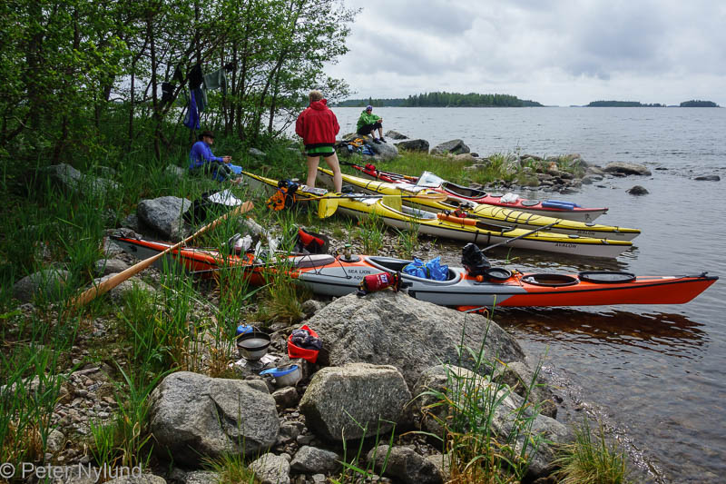
On Monday morning we started the four hour car trip for Turku and started packing our kayaks in the afternoon at the Replot fishing harbour.

A preliminary route for the next two days was now planned, taking into account the weather forecast. We would take the eastern part with Mickelsörarna first, so we started by paddling towards northeast. The weather was sunny and the wind fairly weak.


The weather started to change with dark clouds coming up from southwest.

A landing place was marked on the kayaking map at Västra Harrbådan and we went to check if it would be a suitable place for the night. Because of the landscape is full of stones and the vegetation often very dense, the possible tent places are limited here. The kayaking map contains information about some of these places. There were also a few small islands nearby, the names of which implied slick rocks (names containing "hällan"), but it looked like we could set up four tents on Västra Harrbådan. The dark clouds and a suddenly increasing wind made us take the premature decision of staying at the island for the night, after only 10 km of paddling. We hadn't discovered the red ants yet...


The ants forced us from the best place to sit and eat and then it started to rain.

This was definitely one of the worst tent spots ever for me. The night still went fairly well and I was dry and warm in the tent despite the rain.
It mostly stopped raining for our breakfast.

On the move again.

On the northern tip of Köklot the islands looked a little different. Lots of stones, but pine trees instead of the bushes.


We landed on one for a short break.


Another short break before going out for a crossing with waves that according to the nautical chart and wind direction should be a little bigger.

In shelter again. There are no pictures taken in waves by me, since my kayak really isn't stable enough for that.

Lunch at Kockskäret.
Almost getting through at Rummelholmen.

Mickelsörarna is an archipelago with almost 300 islands, but most of them are difficult to land on and walking on some of the islands would be a real hardcore activity. Because of the weather window for visiting Ritgrund would be on Wednesday, we didn't have time to explore more than a small part of the islands.

For the afternoon coffee we actually found some smooth rocks.

It was now time to turn southwest to get us to Trutören at Märaskäret, which would have us in a good position for Ritgrund.

It started to rain, but it looked like most of the rain passed a bit south of us.

Ritgrund can be seen in the distance just front of Tarja.


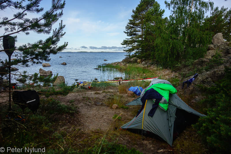
The distance of the day was 33.5 km. The tent spot on Trutören (marked on the paddling map) was a really nice one, with only one drawback: Since there were no longer any wind, there was nothing to prevent the mosquito attacks.


My Aquarius Sea Lion kayak is a tad small for a week-long trip. Everything fits, bút I took a smaller tent and made some compromises with the food. Otherwise it is an excellent kayak.

Bird wetch.

The tent site.

Stones.

Yellow toadflax.

A nice evening.

A game of chess while feeding the mosquitoes.

The night was silent, with the exception of the thousands of mosquitoes trying to get into the tent without success.

The morning was also perfectly acceptable.
Breakfast. I had a lighter one, though.


Common sea-buckthorn is a characteristic plant here.

By now our car drivers had gotten SMS messages about the cars being parked at a very bad place, despite our explicitly asking if everything was ok. They were right on top of the place where some cables were to be digged down and the workers were already waiting to get started. With us being almost a full day of paddling away, our options were somewhat limited. An arrangement was however made and we could start the 8 km open water crossing to Ritgrund.


Ritgrund straight ahead.

A speedboat approached and took delivery of the car keys.

Ritgrund.

Funny clouds.

Getting closer.


The lighthouse is the only one made of tree in Finland.


Harsh surroundings.


It was too early for lunch, so we started the 9 km crossing to southwest in continuing nice weather.

We made lunch at the Björköby fishing harbour, where we also could refill our water supplies. A salad tasted great in the warm weather.

Continuing towards Svedjehamn. The wind soon started rising, but for some reason went through almost all directions.

At Svedjehamn we had coffee and cake at the café, before continuing towards the view tower by kayak. The view showed the De Geer moraines clearly. Click on the picture for a larger view of the panorama.

Tarja stayed in the kayak.

We continued through the labyrinth of moraine ridges.

Now and then we followed the lanes, to avoid too many scratches in the kayaks. We skipped the tent place marked on the map at Långgrund, since it looked like it would have too many mosquitoes.

Closing in on Sondasören, which I had great hopes for being a nice place. The distance of the day was 30.5 km.

Sondasören was great, but it soon started to rain...


No fish yet.

Continued here.
No comments:
Post a Comment